
RF Propagation Analysis over IrreguTerrainlar (RF-PAIT) is a multi-platform application developed in Java for path-loss calculation of VHF-UHF links in mountainous areas or any other area.
This application which is based on Longley-Rice calculation model, is completely field-tested for the precision of its results.
 |
 |
|---|
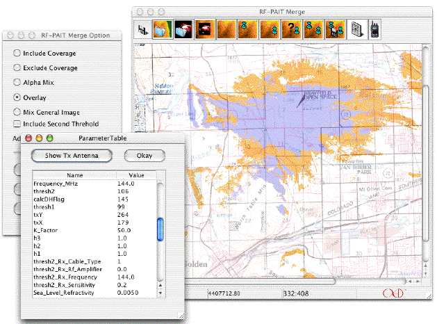
RF-PAIT Merge
Included module.RF-PAIT Merge is used for mixing area coverage maps with elevation color coded maps. RF-PAIT merge is an interactive tool that can be used to overlay the coverage map with the elevation map by adjusting the alpha channel. The desired image can be exported as JPEG or GIF and can be imported into various GIS programs. RF-PAIT Merge also allows for the adjustment of threshold colors and combining the coverage map with elevation maps. Other options include coverage inclusion and exclusion. Top
Some of RF-PAIT's major features are:
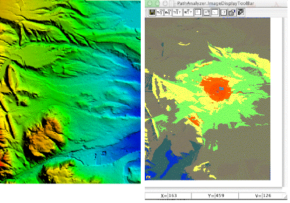
- Graphical results: Calculation results are displayed as graphical images which can be displayed as an overlay on maps.
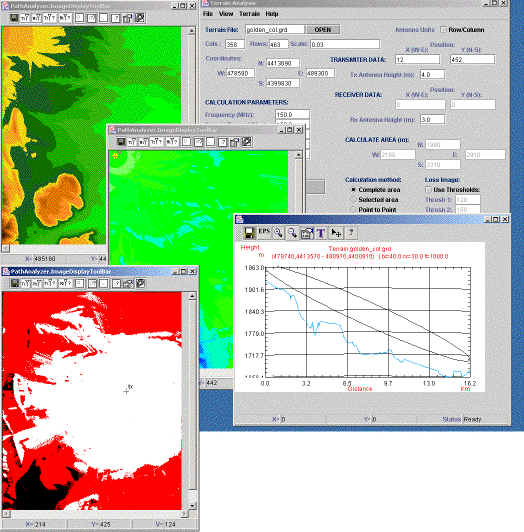
- Full navigation: Displays terrain image as a color-leveled image and displays the UTM coordinates and height of any point, through mouse navigation.
- Cross section of map: Displays a cross section graph by dragging the mouse between two selected points on map.
- 3 Calculation methods:
- Complete Area calculations: only the transmitter's position is set, and path calculations are done for the whole area.
- Selected Area calculations: the transmitter's position and the area needed to be calculated (relative to transmitter position) are specified.
- Point to Point calculations: calculation is made for the path between given transmitter and receiver coordinates.
- Full integration with MapInfo: the results could be directly displayed in MapInfo as a raster layer over the map.
- 2 output modes: The calculation results can be either displayed as a 16-level colored image or as a 3-level threshold image in which the threshold of each level could be independently set. Images for coverage and elevation data are stored in both JPEG and GIF format.
- Written in Java for maximum portability and flexibility. Easy installation in Windows and Linux.
- RFPait works hand in hand with Global Mapper. DEM files are easily converted by Global Mapper to a format for import into RFPait.
- Supported on Windows and Linux 32 bit Platforms. Contact XCAD Corporation for availability on other platforms.
- EPS Export of point to point plots and profiles
- Antenna Height Analysis showing coverage for different antenna heights.
- Interactive transmit and receive antenna placement.
- Forms for inputting transmitter and receiver specifications. Top